
I love maps! By which I mean that I am passionate about them – whether they depict real places or the let's-pretend realms of the imagination.
There cannot be anywhere better to write about the maps in my life than where I am now: Venice – or to be absolutely precise in case you want to locate it on a map: 2316 Calle del Pestrin, San Marco, 30124, Venice. You see Venice is both the most intricately and incompetently mapped city in the world.
When my husband, David, and I arrived here first, almost thirty
years ago, we came clutching The
Illustrated Venice Map by Magnetic North: chosen from Stanfords’ incomparable
emporium, ‘Est. 1853’, at a time when it was the largest, and indeed only, map
maker and seller in London and is still, today, the best starting point for the
ardent traveller. I suspect that I selected this particular map of Venice
(there were, at least, a dozen others) because it had little pictorial indicators
of likely destinations: the Piazza San Marco – la Piazza (‘the Square’) –
the Rialto Bridge, Santa
Maria della Salute and Teatro La Fenice.
It was an Italian sitting next to us on the plane, helpfully advising us how best to reach our hotel with minimal chance of getting lost, who expressed, with surprise, his approval of our map, noting as we would soon discover that, unlike most tourist maps, it shows every calle, campo, ponte and fondamenta, mapping the city down to the shortest, narrowest of blind alleyways. However, it is much more than just that: it is also a map of a state of mind, a glorious figment of historical imagination. It has served us well, its folds worn to yawning slits that defy refolding; and, though rarely now referred to, we carry it still out of sentimentality.
The very first map of which I was aware – long before I understood that places, real or fictional, were capable of beingmapped – was of what I fancy must have been some piratical treasure island. It resided within the red (possibly) covers of a large gift book of tales, verses and puzzles selected to delight the younger reader. As I have it no longer (and, despite years of searching, have never found another) my recollections are imprecise: to my three-year-old self it seemed huge – of the proportions of a lectern Bible – and I hauled it around, insisting that any indulgent adult read to me from its pages.
My favourite story was that of Alice’s expedition into Wonderland that was serialised through the volume, chapter by chapter. But there was another story – pictorially told – of some adventurous, perhaps even swashbuckling, kind that featured a double-page spread, printed, my hazy memory thinks, in black and red and showing a map of an island. I believe I can almost make out its contours: its wavy coastline of coves and creeks; its chief attractions being mountains, forests and lagoons and, maybe, a spot significantly marked with an 'X'. I think of this map, existing now only in faulty memory and having never been seen again, as being mine alone. The next map to which I laid personal claim was, some might say, not a map at all – although I must beg to differ.
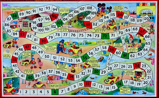
It came folded in half in a box together with a die and four bright plastic cars – green, blue, yellow and red. It was Christmas 1953, I was now four years old, and the radiantly yellow box-lid announced itself as containing ‘Enid Blyton’s LITTLE NODDY CAR GAME. Get to the Station with NODDY and his friends’.

CLICK IMAGE to ENLARGE
A snake of numbered squares crawled back and forth across the gaming board – or, as I knew it to be, a map of the route from Noddy’s house (square 1) to the Station (square 120) through a nursery-coloured landscape dotted with toy houses, roads and rivers, bridges, ferries, traffic lights and level crossings.
CLICK IMAGE to ENLARGE
Making a journey as Noddy was – like all the great literary journeyings from The Odyssey to The Pilgrim’s Progress to Moby Dick – punctuated with all manner of random incidents leading to advances or retreats, dictated here by the roll of a die: ‘Big Ears shows short cut to No. 70’ or (this was in the politically incorrect ‘50s) ‘Golliwogs crossing road, miss turn’. Some fifty years after my mother had given my Noddy map-game to an undeserving cousin, I bought another in an antique centre and was comforted to find that my childhood memories were still intact, from landing on square 30 (‘Downhill advance to No. 35’) to getting stopped by Mr Plod the Policemen on square 80 (‘Fined! Licence out of date, back to No. 25’).
I now jump ten years, to August 1963 when the 14-year old me, now gripped in a passionate obsession with the life and films of Walt Disney, picks up a copy of National Geographic with a lead article (a satisfyingly staggering 50-pages long!) devoted to ‘The Magic Worlds of Walt Disney’ and find that it contains – to my breathless delight – a three-page, foldout pictorial map of Disneyland: a place, like Venice, that is both a reality and a fantasy
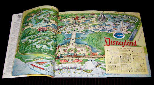
Specially drawn by ‘J E Barrett, Staff Artist’, this is Disneyland before the coming of Pirates of the Caribbean (let alone the unlooked for arrival of Indiana Jones and Star Wars), when pack mules and mine trains still explored Nature’s Wonderland and when it was still possible to ride the Flying Saucers of Tomorrowland.

CLICK IMAGE to ENLARGE
Truthfully, I cannot recall the countless hours in which I pored over that map, drawn back again and again by the pseudo-gothic lettering of ‘Disneyland’ and studying its detail until (had it been possible for me to go to Disneyland) I could have found my way blindfold and without missing a step from the hippo-infested waters of the Jungle Cruise via the blue-roofed towers and turrets of Sleeping Beauty Castle to the helter-skeltering Matterhorn bobsleds.
And when, after an interval of over twenty years, I finally passed through the turnstiles to ‘The Happiest Place On Earth’, I found myself walking, as if in a dream, through those foldout pages of National Geographic: the map and the place metamorphosing into a present experience.
These then were my three ‘personally owned’ maps. My life since has, of course, been crowded with a great many maps with which I have been deeply in love – and about which I have even written books – but which I always knew I shared with others: for example, the puzzling chessboard ‘map’ at the front of Through the Looking-glass; or Moomin Valley with its wolf-topped Lofty Mountains and that enticing off-shore island, home to the enigmatic Hattifatteners; or Bilbo’s Wilderland in The Hobbit with its crooked spine of the Misty Mountains marking the frontier beyond which lay the cobwebbed forest of Mirkwood and greater perils yet.

Then there have been those cosily reassuring maps made by E H Shepard: of Winnie-the-Pooh’s ‘100 Aker Wood’ and its surroundings (including the best-ever map location: ‘Where the woozle wasn’t’); and the rural home of the inhabitants of The Wind in the Willows with a river–– No! Sorry, Ratty, The River! – curling its way from Toad Hall to Pan Island and the Weir beyond. Or Pauline Baynes’ ornate charts of Narnia and Middle-earth: as evocative as the work of any fifteenth-century cartographer and meticulously embellished with cartouches portraying the various sites in the stories – Cair Paravel or Minas Tirith – realised in gleaming gem-like colours.

None of these, however, can ever truly supplant those earliest depictions of the ordered middle-class world of Noddy’s 1950s Toyland; or the ever-beckoning pleasures Disney’s Garden of Earthly Delights as it was in the early ‘60s; or, again, that long-lost, foggily-recalled mysterious island map that first lured an unsuspecting three-year-old into succumbing to the unappeasable dreams of Elsewheres and Othertimes.
[Written in Venice, December 2016; Revisited in London,2023]

No comments:
Post a Comment